
Comprehensive Plan
Lago Vista map fight over a ranch capped at 568 homes
Lago Vista's draft map labels Shoreline Ranch rural. A former mayor speaking for the ranch wants the label its owners say fits their zoning.
Correction, October 1, 2026. An earlier version of this story and its headline said a Neighborhood Residential label could guide Shoreline Ranch to as many as 2,164 homes. That figure multiplied all of the owner's acreage by the label's top density. The ranch's zoning caps it at 568 homes, and a map label does not change that cap. An earlier summary also described Kevin Sullivan's request as seeking a denser label. He has said the label would match the entitlements the ranch already has. We removed the figure, the related home counts, and that description.
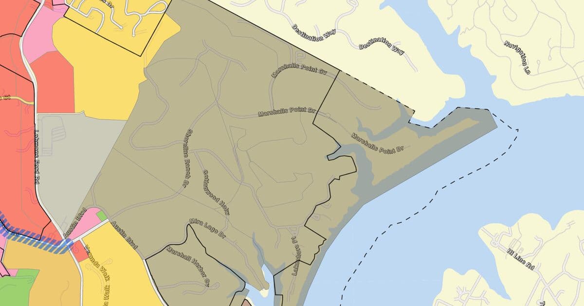
The Lago Vista City Council's Oct. 1 agenda asks it to act on an update to the city's Comprehensive Plan. The update comes as a recommendation from the Planning and Zoning Commission.1 The plan includes a Future Land Use Map (FLUM), which the city calls a long-range policy guide.2 The council is also asked to give staff direction on the next draft.1 Shoreline Ranch Texas LP owns 130 parcels covering 540.96 acres inside city limits, according to county appraisal records.3 The ranch's zoning, a planned development district (PDD), caps it at 568 homes.45 The commission's map marks Shoreline Ranch Rural Residential Tier 1.6 That label guides land to no more than 0.33 homes per gross acre, on lots of at least 3 acres.7 Former Mayor Kevin Sullivan said in August that Shoreline Ranch representatives had engaged him.8910 He wrote the council that he would ask for the Neighborhood Residential label. He wrote that the ranch "has entitlements on the property that are equivalent to" that label.11 The staff report says the map does not rezone property or create development entitlements. But the map feeds the city's utility planning. A utility map still to come will show the infrastructure needed to serve the land uses the plan expects at buildout.2 The city's water and wastewater master plans call for $153.3 million and $90.9 million in capital projects to serve about 20,000 connections at buildout. The plans say most of those projects are eligible for impact fees.1213 But the wastewater plan says some repairs "must be paid for from the utility fund rather than impact fees."13 The plan rewrite began with a 2023 Halff Associates contract that grew to $240,000 after a math fix.141516 The first $200,000 was budgeted in the General Fund.14
Listen
A two-host briefing. The voices are AI generated. Read the transcript.
We wrote this story before the City Council met on Oct. 1. It does not report what happened at that meeting.
Acreage totals and the sum of the two master plans' costs in this story are our calculations from the cited records.
What the map does
The map matters because a 2023 city rule ties zoning changes to it. Under Ordinance No. 23-01-19-03, "no zoning application deemed to be inconsistent with the Comprehensive Plan shall be considered" until the owner first wins a plan amendment. That amendment takes the vote of at least three-fourths "of all members of the governing body." The same ordinance says an application "shall in no way bind the City Council to amend the Comprehensive Plan."17
The labels on the map
Each area on the map gets a place-type label, and the labels for housing areas carry guidance on how many homes an acre the land should hold.7 The council adopted the Lago Vista 2030 Comprehensive Plan in May 2016. Its map uses Rural Residential, Estate Residential, and Low Density Residential for lower density homes. Rural Residential means fewer than 0.2 homes an acre. Estate Residential means 0.3 to 1, and Low Density Residential means 2 to 3.18
Halff Associates, the city's consultant, helped write a 2025 draft plan. At an open house, people disagreed about where its draft map placed "Lifestyle Neighborhood" and "Conservation Estate."19 The draft plan in the packet for an October 2025 work session uses the three older labels.1819
City staff wrote a new draft dated February 2026 with 11 place types, including three tiers of rural residential.2 Rural Residential Tier 1 guides land to no more than 0.33 homes per gross acre, on lots of at least 3 acres. Tier 2 guides land to 0.3 to 1.0 homes per gross acre on lots of at least 2 acres. Tier 3 guides land to about 1.0 home per gross acre on lots of at least 1 acre. Neighborhood Residential covers detached single-family neighborhoods. It guides land to 1 to 4 homes per gross acre, on lots that match established subdivisions. Neighborhood Transition guides land to 4 to 8 homes per gross acre on lots of about 0.20 acres. It is mapped next to detached-home neighborhoods, where height and intensity must step down.7
| Place type | Homes per gross acre | Typical lot |
|---|---|---|
| Rural Residential Tier 1 | 0.33 or fewer | 3 acres or more |
| Rural Residential Tier 2 | 0.3 to 1.0 | 2 acres or more |
| Rural Residential Tier 3 | About 1.0 | 1 acre or more |
| Neighborhood Residential | 1 to 4 | Matches established subdivisions |
| Neighborhood Transition | 4 to 8 | About 0.20 acres |
Staff say this place-type guidance does not create zoning or development entitlements.2 It is meant to help the city weigh future land use decisions, rezonings, and amendments.7 The staff report says the map itself "does not rezone property."2
How it started
Shoreline Ranch sits along Shoreline Ranch Drive, east of Lago Vista High School.5 It was zoned as a planned development district long before this map update. A 2021 staff report says an earlier ordinance for the district allowed at most 201 homes.4 A 2007 change cut about 17 acres from the district and raised the cap to 568 homes.45 In 2021, TerraMark Ventures applied to raise the cap to 1,360 homes.4 In April 2022, Mayor Ed Tidwell announced that the applicant had withdrawn the request.2021
- 1,360withdrawn April 7, 2022
- 568maximum allowed today
- 201maximum allowed
Today, Shoreline Ranch Texas LP owns 130 parcels in the area, and most list a latest deed dated Jan. 11, 2022.3 In August 2022, TerraMark wrote to city leaders for the owner. The letter said the 2030 plan "incorrectly shows" the land as Rural Residential. It said the cap of 568 homes on 322 residential acres put the property in the "Low Density Residential" category.22 City records describe the 2030 plan's label differently, as "Estate Residential" or "POA Park" in 2023 and as Rural Residential and "POA Park" in 2025.523 In October 2022, the Planning and Zoning Commission voted "all in favor" to recommend low-density residential for the land.24
2023, a new rule and a denial
In January 2023, the council approved the rule that ties zoning to the map, by a 4 to 3 vote.1725 Council Member Gage Hunt made the motion and Council Member Kevin Sullivan seconded it. Council Members Rob Durbin, Chelaine Marion, and Paul Roberts voted no.2125
In July 2023, the council voted unanimously to hire Halff to update the plan.26 The contract's base price was $235,000, including $60,000 for a parks master plan.14 In December, staff reported that Halff had made a $5,000 math error in its total.16 The council voted unanimously to approve the amendment "in the amount of $240,000."15
In August 2023, the council held a hearing on changing Shoreline Ranch on the map to low-density residential.2123 Sullivan, then a council member, said a new label would not automatically mean more than 568 homes.62127 He said that until the city upgraded its water and wastewater facilities, "it would be criminal on our part to approve more than that."27 Later he said that asking for all of it to be low density "seems like a naked attempt to increase the density on that parcel."628
Mayor Tidwell moved to approve the ordinance, and the motion died without a second. Sullivan then moved to deny it, and the council voted 6 to 1 to deny it, with Tidwell voting no.21
2024 and 2025, a draft no one adopted
The council added more Halff work in 2024 without a price in its motion.29 That September, the council voted 6 to 1 to have Halff hold one more meeting with the council and the plan's advisory committee.929 The motion asked staff and Halff to keep the added costs down "as much as possible."29 Halff's price list put an extra advisory committee meeting at $6,500 and more administration and plan revisions at $4,200.30
In December 2024, the council and the advisory committee met to hear an update from Halff.9 Council Member Paul Roberts said, "I desire to not see a future land use map that's abundantly in conflict with underlying zoning that's already in place." He added, "But I think it needs to be consistent."31
Later that night, a Halff consultant summed up the talk about undeveloped land east of Lohman's Ford Road. The consultant said, "it sounds like, in general, we want to downgrade this lifestyle neighborhood to perhaps the low-density residential neighborhood or lower."32
The proposed plan reached a joint council and commission work session in October 2025.33 A commissioner who said she had led an advisory committee subcommittee said Halff's product "did not reflect what the will of the community was." She said it "was very driven towards higher density."34 Mayor Kevin Sullivan said, "I think we have to be super careful about how tough we want to be on developers."3335 The meeting ended with a decision "to create two sub-committees" to work on the plan and plan a town hall.33
2026, the commission redraws the map
The map now before the council is based on a markup two commissioners made in February.2 On Feb. 22, commissioner Gene Harris posted the marked-up map on the city's online council forum.3637 He said he and commissioner Dave Stewart "came up with" it.36 In March, the commission voted 6 to 0 to form a subcommittee, proposed by Chair Lynda Aird, to revise the draft.38 In May, the commission voted 5 to 0 to send the subcommittee's summary on with amendments.39
In June, the council "directed the plan to go back to sub committee, staff and planning and zoning."40 Later that month, council members agreed by consensus that the budget and charter review came first. They said plan and map updates "may need to be deferred."10 A July staff memo from Development Services Director Jordan Strohmeyer said the council had directed staff to keep the 11 place types.4142
At the commission's July 9 meeting, Sullivan spoke in public comment about a hotel project. He said the map is not a regulatory document but "because of our other ordinances it acts like it's a regulatory document."43 Roberts, by then a former council member, spoke a few minutes later.114445 He said that when land gets a zoning change or is platted, "you want to have that reflected in your future land use map." He tied that to "the very reason mayor Sullivan had pointed out."44
The commission then voted 4 to 1 to recommend the 11 place types and the February density guidance, draft minutes show. The motion made "the Harris/Stewart February 22 marked-up FLUM map and" legend the basis for the new map. It told staff not to change any marked designation unless the council directs otherwise.45
August, Sullivan speaks for Shoreline Ranch
In August, Sullivan told the commission and then the council that he was representing Shoreline Ranch.846 At the commission's Aug. 13 meeting, Sullivan spoke during citizen comments on items not on the agenda. He said that since the commission's last meeting, "Shoreline Ranch representatives have engaged me to help them walk through the PDD amendment process."8
Of the January 2023 ordinance, he said, "I was someone who voted for it, and I'm part of the problem."47 He asked that the map label for Shoreline Ranch be changed to Neighborhood Residential. He also asked the commission to have the council send the map back. He said the new label would only give the owner "the opportunity to ask for a modification to our PDD."48 Council liaison Paul Prince told him the council saw the budget and the charter as higher priorities.4950 A commissioner then told Sullivan, "the map you're holding was not accepted by P&Z."51
On Aug. 20, Sullivan told the City Council, "I specifically was representing Shoreline Ranch, and I discussed their situation." He asked the council to consider sending the map back to the commission for more discussion.46
The packet and the emails
In the days before the meeting, Sullivan and Roberts made their cases to the council by email.611 The first version of the meeting packet had the staff memo for the item but no attachments.52 On the morning of Sept. 29, Sullivan emailed the mayor and council, who were blind copied. He wrote that neither the plan nor the map "you are considering is included in the packet."11 Later versions added a place-type table, a draft map dated July 27, and a photo of a hand-marked map.535455 Its two pages are the same image files Harris attached to his Feb. 22 forum post.3655
In his Sept. 29 email, Sullivan wrote that he planned "to speak on behalf of Shoreline Ranch." He would "specifically request a Neighborhood Residential designation on the FLUM for that property," he wrote. In his words, "The current land owners of Shoreline Ranch acquired the property in 2022." A wrong map label and the 2023 ordinance, he said, left the owners in "a Catch 22 situation." The owners want the label aligned with their entitlements, he said. That way they can seek a PDD amendment that is "modern, market driven, and has a chance for success." He also said a map Strohmeyer placed in the July 9 commission meeting showed Shoreline Ranch as Neighborhood Residential.11 A staff draft map dated June 23 in that meeting's packet labels the land along Shoreline Ranch Drive Neighborhood Residential. Strohmeyer's July 9 memo said that draft map "is not intended to represent a final staff" recommendation.41
Roberts emailed city staff that evening, with the mayor and council blind copied. He asked the council to "decline the requested substitution of Neighborhood Residential." His July 9 remarks, he said, were about the hotel approval. "I did not intend those remarks as an endorsement of Neighborhood Residential for Shoreline Ranch," he wrote. If a developer's profit depends on later changes, he said, "that is the purchaser’s business risk." The 2023 ordinance, he said, "expressly preserves Council’s discretion over the comprehensive plan." He asked the council to "establish a definite timetable" to finish the plan.6
Sullivan wrote again early on Oct. 1. Of the Dec. 19, 2024 meeting, he wrote, "We instructed the Halff representative to designate the land as Neighborhood Residential."11 The video of that meeting shows the consultant's "downgrade" summary quoted above, and the minutes record no map vote.932 Moments later, a speaker said the undeveloped area "should be either residential neighborhood or conservation estate."32 Sullivan urged the council to "confer with legal" about treating landowners differently and wrote, "That just seems ripe for legal liability." He wrote that for Senate Bills 840 and 15, "there was a small city carve out that allowed us to ignore those laws."11
Both 2025 bills apply only to cities of more than 150,000 people that are at least partly in a county of more than 300,000.5657 The 2020 Census counted 8,896 people in Lago Vista.58 Neither bill's text names any other exemption for small cities.5657
What it costs taxpayers
Shoreline Ranch Texas LP was the city's top taxpayer on the 2023 certified roll, with $34,191,146 in taxable value.59 On the 2025 roll, its taxable value was $8,454,990. The records we reviewed do not say why the value fell.60
The final Water Master Plan, presented for adoption in March 2025, projects 20,386 water connections at full buildout, up from over 5,300.12 Together the two plans come to $244.2 million in capital projects, mixing 2023 and 2024 dollars. Both plans call these figures construction cost estimates. They say fees for "design, surveying, environmental studies, geotechnical studies, land acquisition, legal fees, etc. are not included."1213
The 2022-23 budget put $200,000 for the "Comprehensive Plan" in the General Fund's Development Services professional services line.61 That line spent $172,250 in 2023-24 and $161,838 in 2024-25, and it has $0 approved for 2026-27. The budget does not break out how much of that line went to Halff.62
Where it stands
The Oct. 1 staff report asks the council for direction on five points. They include the 11 place types, the map's labels, and any use of Rural Residential Tier 3. Staff also asks whether to prepare the next draft and the public hearing. Staff noted that the marked-up map did not place any land in Rural Residential Tier 3. A thoroughfare map, an evacuation map, and a utility and infrastructure map are still being drawn. The item report we reviewed has no recommendation line and no financial impact line.2 Our next story will report what the council decided.
What we could not find
- The full text and council votes for Ordinance 02-09-26-01 and Ordinance 07-10-18-01, which amended it, since we have seen only summaries of their terms.45
- The price of the 2024 Halff add-on and the total the city has paid Halff.2962
- Any 2026 map amendment application from Shoreline Ranch, and the presentation and timestamp file Sullivan sent the council.11
- Why Shoreline Ranch's taxable value fell from $34,191,146 in 2023 to $8,454,990 in 2025, and who the partners of Shoreline Ranch Texas LP are.5960
- How much of the water and wastewater capital projects impact fees would pay for, since the plans say which projects are eligible for the fees but not how much the fees would raise.1213
What you can do
- File a Texas Public Information Act request on the city's records request page for all correspondence to council members and Planning and Zoning commissioners about Shoreline Ranch or the FLUM since Aug. 1, 2026, including Sullivan's presentation and attachments.63
- Ask for Halff Associates invoices and payments under the 2023 contract and the 2024 add-on.63
- Ask for the computer map files behind the July 27 draft map.63
- Speak at citizen comments at a council or Planning and Zoning Commission meeting.164 The meeting notice says you must submit a completed form first.1
If you have records on this, you can share them with us at /share-records. We protect your identity and publish the evidence when we can do so safely.
Email alerts
Get the next story by email
We email you when a person has checked a new story against the record and it goes live. No ads, no tracking.
Podcast transcript
Read the transcript
Host 1. This is the Lago Vista Watchdog briefing. The two voices you are hearing are AI generated. Every fact in this episode is sourced in the full story on our website, and a person validates each story before it is published. We made this episode before the City Council met on October 1, and it does not report what happened at that meeting.
Host 2. Here is the bottom line. The City Council's October 1 agenda asks it to act on an update to the city's Comprehensive Plan. The update comes as a recommendation from the Planning and Zoning Commission. The plan includes a future land use map, which the city calls a long-range policy guide.
Host 1. One property is at the center of the debate. County appraisal records show Shoreline Ranch Texas LP owns 130 parcels covering 540.96 acres inside city limits. The ranch's zoning caps it at 568 homes.
Host 2. The commission's map marks Shoreline Ranch Rural Residential Tier 1. That label guides land to no more than 0.33 homes per gross acre, on lots of at least 3 acres. Former Mayor Kevin Sullivan said in August that Shoreline Ranch representatives had engaged him. He wrote the council that he would ask for the Neighborhood Residential label. He wrote that the ranch has entitlements on the property that are equivalent to that label.
Host 1. The staff report says the map does not rezone property or create development entitlements. But the map feeds the city's utility planning. The city's water and wastewater master plans call for 153.3 million dollars and 90.9 million dollars in capital projects. The plans say most of those projects are eligible for impact fees. But the wastewater plan says some repairs must be paid for from the utility fund.
Host 2. And the plan rewrite itself began with a 2023 contract with the consulting firm Halff Associates. It grew to 240,000 dollars after a math fix. The first 200,000 dollars was budgeted in the General Fund.
Host 1. Why does the map matter? A 2023 city rule says a zoning application that conflicts with the plan cannot be considered until the owner first wins a plan amendment. That amendment takes three fourths of the whole council.
Host 2. A quick guide to the labels. Each area on the map gets a place-type label. City staff wrote a new draft in February 2026 with 11 place types. Rural Residential Tier 1 guides land to no more than 0.33 homes per acre. Neighborhood Residential guides land to 1 to 4 homes per acre, on lots that match established subdivisions. Staff say this guidance does not create zoning or development entitlements.
Host 1. Now, in order, here is how we got here. A 2021 staff report says an earlier ordinance for the district allowed at most 201 homes. A 2007 change raised the cap to 568. In 2021, TerraMark Ventures applied to raise the cap to 1,360 homes. The applicant withdrew that request in 2022.
Host 2. In August 2023, the council held a hearing on changing Shoreline Ranch on the map to low density residential. Sullivan, then a council member, said asking for all of it to be low density seems like a naked attempt to increase the density on that parcel. The council voted 6 to 1 to deny the change.
Host 1. In December 2024, Council Member Paul Roberts said he did not want a future land use map that's abundantly in conflict with underlying zoning. Later that night, a Halff consultant summed up talk about land east of Lohman's Ford Road as a possible downgrade to low density residential or lower. Moments later, a speaker said the undeveloped area should be either residential neighborhood or conservation estate.
Host 2. In 2026, the commission redrew the map. Commissioner Gene Harris posted a marked-up map on the city's online forum in February. He said he and Commissioner Dave Stewart came up with it. In July, the commission voted 4 to 1, according to draft minutes, to recommend the 11 place types and to use that map as the basis for the new one.
Host 1. In August, Sullivan told the commission that Shoreline Ranch representatives had engaged him to help them walk through the amendment process. He told the council, I specifically was representing Shoreline Ranch.
Host 2. Then came the emails to the council. On September 29, Sullivan wrote that he would request Neighborhood Residential, and that the owners were stuck in what he called a Catch 22. He said a staff map at the July 9 meeting showed the land as Neighborhood Residential. A June 23 staff draft in that meeting's packet does label it that way.
Host 1. That evening, Roberts, now a former council member, asked the council to decline the change. He wrote that if a developer's profit depends on later changes, that is the purchaser's business risk.
Host 2. Early on October 1, Sullivan wrote again. He wrote that in December 2024, the council instructed Halff to designate the land as Neighborhood Residential. The minutes of that meeting record no vote on the map.
Host 1. The staff report for the October 1 item has no recommendation line and no financial impact line. A utility and infrastructure map is still being drawn. We will report what the council decided in our next story.
Host 2. To weigh in, you can speak during citizen comments at a council or Planning and Zoning meeting after filling out the comment form. You can also file a public records request on the city's website for letters and presentations sent to the council about Shoreline Ranch. The full story, with every source, is at lagovistawatchdog.com.
Sources and documents
Every fact in this story comes from the records below. The small numbers in the story point to them. Links go to the exact moment in the meeting video or the page in the document.
- City Council agenda, October 1, 2026, Item VIII.3
- City Council agenda packet, October 1, 2026, Item VIII.3 staff report on the Comprehensive Plan and FLUM See p. 38.
- Travis Central Appraisal District, 2026 property records for owner Shoreline Ranch Texas LP (owner ID 1921198), 130 parcels
- City Council agenda packet, April 7, 2022, staff land use report on the Shoreline Ranch PDD (Case 21-1921-PDD-MOD) See p. 139.
- City Council agenda packet, April 17, 2025, staff table of potentially dormant entitlements See p. 402.
- Email from former council member Paul Roberts to city staff, with the mayor and City Council blind copied, on the October 1 FLUM item, September 29, 2026 Published by Lago Vista Watchdog, PDF.
- City Council agenda packet, October 1, 2026, Future Land Use place types table and descriptions See p. 41.
- Planning and Zoning Commission meeting video, August 13, 2026, Kevin Sullivan citizen comment At 0:02:23.
- City Council minutes, December 19, 2024 See p. 2.
- City Council minutes, June 18, 2026 See p. 7.
- Emails from former mayor Kevin Sullivan to city staff, with the mayor and City Council blind copied, on Shoreline Ranch and the FLUM, September 29 and October 1, 2026 Published by Lago Vista Watchdog, PDF.
- City Council agenda packet, March 6, 2025, Resolution No. 25-2120 and final Water Master Plan See p. 98.
- City Council agenda packet, April 18, 2024, Wastewater Master Plan executive summary See p. 91.
- City Council agenda packet, July 6, 2023, Halff Associates comprehensive plan contract See p. 140.
- City Council minutes, December 7, 2023 See p. 4.
- City Council agenda packet, December 7, 2023, Halff Associates agreement amendment See p. 18.
- City Council agenda packet, January 19, 2023, staff memo and Ordinance No. 23-01-19-03 See p. 118.
- Lago Vista 2030 Comprehensive Plan, adopted May 5, 2016, as amended, residential land use types See p. 39.
- City Council agenda packet, October 16, 2025, draft 2025 Lago Vista Comprehensive Plan and Parks Master Plan by Halff, open house summary and residential land use categories See p. 194.
- City Council minutes, April 7, 2022 See p. 5.
- City Council minutes, August 3, 2023 See p. 4.
- Planning and Zoning Commission agenda packet, October 13, 2022, TerraMark Ventures letter on the Shoreline Ranch FLUM See p. 231.
- City Council agenda packet, August 3, 2023, Ordinance 23-08-03-05 (Shoreline Ranch FLUM amendment) See p. 401.
- Planning and Zoning Commission minutes, October 13, 2022 See p. 8.
- City Council minutes, January 19, 2023 See p. 5.
- City Council minutes, July 6, 2023 See p. 4.
- City Council meeting video, August 3, 2023, Shoreline Ranch FLUM hearing At 1:21:20.
- City Council meeting video, August 3, 2023, Shoreline Ranch FLUM hearing, later remarks At 1:53:38.
- City Council minutes, September 5, 2024 See p. 4.
- City Council agenda packet, September 5, 2024, Halff additional services See p. 137.
- Joint City Council and Comprehensive Plan Advisory Committee meeting video, December 19, 2024, Paul Roberts on the draft map At 0:21:57.
- Joint City Council and Comprehensive Plan Advisory Committee meeting video, December 19, 2024, Halff summary on the east side At 1:10:58.
- City Council minutes, October 16, 2025 See p. 7.
- Joint City Council and Planning and Zoning Commission workshop video, October 16, 2025, P&Z member on the Halff draft At 2:31:23.
- Joint City Council and Planning and Zoning Commission workshop video, October 16, 2025, the mayor on developers At 3:45:09.
- City of Lago Vista council forum, "FLUM Maps (Comp Plan)," Planning & Zoning Commission section, February to April 2026
- Planning and Zoning Commission agenda packet, March 12, 2026, draft minutes of February 26, 2026 See p. 12.
- Planning and Zoning Commission agenda packet, May 14, 2026, draft minutes of March 12, 2026 See p. 13.
- Planning and Zoning Commission agenda packet, June 11, 2026, draft minutes of May 14, 2026 See p. 102.
- City Council minutes, June 4, 2026 See p. 6.
- Planning and Zoning Commission agenda packet, July 9, 2026, staff memo on the Comprehensive Plan draft and the June 23, 2026, draft map See p. 128.
- City Council minutes, June 18, 2026, rezoning of 7301 Lohman Ford Road See p. 4.
- Planning and Zoning Commission meeting video, July 9, 2026, Kevin Sullivan public comment At 2:39:36.
- Planning and Zoning Commission meeting video, July 9, 2026, Paul Roberts public comment At 2:44:21.
- Planning and Zoning Commission agenda packet, August 13, 2026, draft minutes of July 9, 2026 See p. 10.
- City Council meeting video, August 20, 2026, Kevin Sullivan citizen comment At 0:09:11.
- Planning and Zoning Commission meeting video, August 13, 2026, Kevin Sullivan on the January 2023 ordinance At 0:04:47.
- Planning and Zoning Commission meeting video, August 13, 2026, Kevin Sullivan request and council liaison answer At 0:12:17.
- Planning and Zoning Commission meeting video, August 13, 2026, council liaison Paul Prince on council priorities At 0:10:46.
- Planning and Zoning Commission amended agenda, August 13, 2026
- Planning and Zoning Commission meeting video, August 13, 2026, responses to Kevin Sullivan At 0:13:42.
- City Council agenda packet, October 1, 2026, first version (70 pages), Item VIII.3 See p. 40.
- City Council agenda packet, October 1, 2026, second version (83 pages), Item VIII.3 attachments See p. 40.
- City Council agenda packet, October 1, 2026, draft Future Land Use Map drafted July 27, 2026 See p. 53.
- City Council agenda packet, October 1, 2026, current version (85 pages), hand-marked map attachment See p. 55.
- Texas Senate Bill 840, 89th Legislature, Regular Session (2025), enrolled version
- Texas Senate Bill 15, 89th Legislature, Regular Session (2025), enrolled version
- U.S. Census Bureau, 2020 Census, Table P1, Lago Vista city, Texas
- Travis Central Appraisal District, 2023 adjusted certified totals for the City of Lago Vista, top taxpayers See p. 10.
- Travis Central Appraisal District, 2025 adjusted certified totals for the City of Lago Vista, top taxpayers See p. 11.
- City of Lago Vista adopted budget, 2022-23, Development Services See p. 41.
- City of Lago Vista adopted budget, 2026-27, General Fund Development Services See p. 18.
- City of Lago Vista, Open Records Request page
- Planning and Zoning Commission agenda packet, August 13, 2026, draft minutes of June 11, 2026 See p. 5.
See something wrong? Request a correction. Have records on this? Share them with us.